111,163.2 PERCH
An ongoing behind-the-scenes project involves researching historical information related to the Yorklyn area so that the National Register of Historic Places documents written in the 1970s for the Auburn area and the Garrett Snuff Mills area may be updated and reissued. Research hopes to add Oversee Farm to the revised listing as the farm’s history extends back to the time of William Penn as well. An aspect of this work has been to understand exactly what land John Garrett and his descendants owned in the Auburn area. All the land from Oversee Farm west into Pennsylvania was part of Letitia Manor. Letitia Manor was the eastern 15,500 acres of the 30,000-acre Manor of Steyning that William Penn gifted his son, William, Jr., and daughter Letitia Penn Aubrey.
John Garrett purchased property along the Red Clay Creek in 1728 with a vision to construct a grist mill. The mill became operable with Garrett and four local farmers in the 1830-31 timeframe. John would go on to buy additional lands in the area as would his only son, John II. One of John II’s sons, Horatio Gates Garrett, eventually took over ownership of the grist mill and 114 surrounding acres that encompassed the Red Clay Creek and included the mill race and dam. Horatio converted the mill to the making of paper. Eventually the 114-acre parcel and mill would be owned in turn by Thomas Lea, Jacob Pusey, and the Clark brothers who did textile milling at the site before the mill was purchased by the Marshalls in 1890 to be returned to making rag paper.
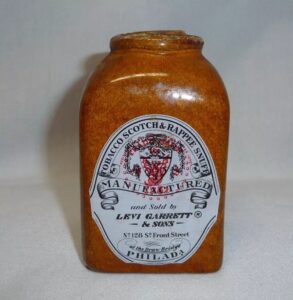
 In 1782, after serving the 6th Delaware Militia Company during the revolution, John II, took up an interest in milling tobacco into snuff a short distance downstream of his original grist mill. John II’s sons Levi, Thomas, and William would all join him in the snuff business. The Garretts milled their snuff and bulk shipped it in hogsheads to the Garrett’s Philadelphia store where the snuff was packed into bottles before distribution throughout the young country. Eventually, the operation became Levi Garrett & Sons Snuff Company in the 1820s, and later the William E. Garrett Snuff Company (a son of Levi). As the company grew and expanded, the Garrett family increased their land holdings around the present day Yorklyn area.
How many acres of land, in and around today’s Yorklyn, could the Garrett family claim an ownership of, between 1728 and 1907?
Answer
We believe John’s earliest land purchase amounted to 133.5 acres. The problem with knowing exactly what land John initially bought is that it was described in a very early metes & bounds methodology. The metes & bounds method of documenting land ownership begins at a marked point and follows the land’s perimeter, usually in a clockwise direction, with a written description. Unfortunately, those early descriptions read not unlike this fictitious one:

Northwest, Southeast, Southwest, all encompass a bearing that could be anywhere between 0 and 90-degrees. Without detailed magnetic degrees, minutes, and seconds, it is difficult to know that what direction to walk. The units of measure, chains & links, are only as accurate as the chain might be pulled tight (8 chains and 66 links equates to 571.6 feet). The deed books until the early 1900s were handwritten in cursive script as the above example is. Handwriting varies and make readability of some deeds difficult. The use of quill pens initially, followed by fountain pens before the use of typewriters in the early 1900s, means the handwritten strokes of the letters vary in thickness and intensity. An additional complication is that the Earth’s magnetic field moves about the North Pole over time and thus boundaries in 1700 have shifted by 2024. The magnetic effects, and other variables like roads being abandoned while others are more recent additions, coupled with the Red Clay Creek having moved varying amounts, must be considered in plotting land parcels today that were measured and documented one and two centuries ago.
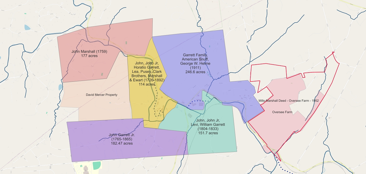
Starting with deeds to land owned in the 21st century, we can work back through nearly 1,000 New Castle County land parcel deed books dating to before the time of William Penn to figure out the answer to this month’s Question & Answer. The map below displays those results. The answer to this month’s Question & Answer is 694.77 acres or 111,163.2 square perches (where the Q&A’s title originates). The perch is an old English unit of measure, a later replacement for links and chains, both still legal measurement in the U.S. A ‘perch’ for land length measurement equates to a length of 16.5 feet or when measuring land area, a ‘perch’ equals 0.00625 acre.
Included as reference is the initial land John Marshall bought in Kennett Township a portion. A portion of Marshall’s land is preserved by the Land Conservancy for Southern Chester County. Likewise, we have included Oversee Farm for reference with the pink area being what is now part of Auburn Valley State Park while the red line is what Eleanor Marshall (Tom Marshall’s cousin) originally purchased in 1952 but later sold portions of to a developer. The dotted blue lines are the mill race locations for the first and second Garrett mills. The David Mercer property is included as much of it below the DE/PA border is today part of Auburn Valley State Park and hosts the Auburn Valley Trail.

We believe John Garrett originally owned the complete 114-acre yellow shaded area which eventually was owned by each of those subsequently named between 1726 and 1892 when the mill simply became Marshall Brothers Mill. 182.5 acres that John Garrett Jr. purchased in 1765 is at the lower left (violet). The green and light blue properties represent roughly what Levi Garrett owned when he passed away and the land was transferred to his son William Evans Garrett in 1833. That land would be reduced to 246.6 acres by the time it passed out of Garrett Family ownership and into the hands of American Snuff Company on April 22, 1907. The 122-acre Ferree farm that eventually was purchased by the Marshalls for National Fibre & Insulation Company (National Vulcanized Fiber Company) lies within the green parcel in the map above.
A century after John Garrett settled on the Red Clay with hopes of building a grist mill, his descendants had introduced snuff milling to the area. A century and a half after John’s settling along the Red Clay, his descendants transformed the area in the snuff capital of the world. Between the snuff mills and the Pusey/Clark cotton/woolen mill, the area had a population peaking around 500 people by the time the railroad arrived in 1872. Two centuries after John’s arrival, snuff would no longer be manufactured in the area as another transformation was occurring with Yorklyn becoming the vulcanized fiber capital of the world. Three centuries following John’s arrival, much of the area once owned by the Garrett family is preserved as Auburn Valley State Park.
As a footnote to the above story, and probably why William E. Garrett had his daughters suggested the name of Yorklyn for the Wilmington & Western Rail Road’s new station, is that there was already a town named for the Garrett family. Garrettsville, Ohio was established in the early 1800s by another of John Garrett II’s sons, (Colonel) John Garrett Jr. John grew up in New Castle County and moved his family to Portage County in Ohio where he settled on Eagle Creek and constructed a mill. A town soon grew up around the location. Garrettsville is located approximately midway between Cleveland and Youngstown.
