This year marks Tom Marshall’s 100th birthday had he lived a few more years. Thinking about Tom’s century mark, and considering that July is our Nation’s birthday, it also means in two years this nation will celebrate its 250th birthday. Additionally, 2026 marks the 300th anniversary (1726-2026) of John Garrett settling on land now anchoring much of Auburn Valley State Park. With four other settlers, Garrett constructed a grist mill (1730-31) whose foundations remain the basement core of Marshall Brothers Paper Mill.
This year, 2024, is the 340-year anniversary (1684-2024) of John Marshall’s emigration to America. Settlers began arriving in America long before William Penn was deeded the Province of Pennsylvania. Penn began the first mass migration of Europeans to America when twenty-two ships arrived between 1681 and 1682. The ship’s passengers settled around already established New Castle, Wilmington, and Philadelphia. Records of who arrived on each ship as part of Penn’s colonization effort were not recorded but it is known that William Penn arrived on the sailing ship ‘Welcome’ which was the nineteenth ship full of Penn colonists to arrive in America.
John, in his early 20s, emigrated to the New World from Youlgreave, Elton Parish, Derbyshire, England in 1684 two years after the initial surge of Penn settlers arrived. Much of the land immediately around Philadelphia had been spoken for by John’s arrival and thus John initially settled 5½ miles west of the city’s first City Hall (on 2nd Street in Penn’s time). John’s cousin, Abraham Marshall (first cousin to botanist John Bartram; Abraham became known as the father of American dendrology or the study of trees), would not arrive in America until 1697.
 We know from the genealogy research of others that after John (1661-1729) arrived in America, he initially settled east of Cobbs Creek in territory eventually becoming known as Blockley Township, Philadelphia County. John later purchased large tracts of land a bit further west in newly formed Delaware County on the west side of Cobbs Creek. His son Thomas (1694-1740) purchased land nearby and most likely subdivided that property later with his son Thomas Marshall, Jr. (1727-1759). Thomas, Jr. was the fifth of nine children, and brother to the eighth born, John Marshall (1734-1815). John relocated to Kennett Township with his two children in 1765 after the death of his first wife. Descended from John are the Marshalls of Auburn Heights.
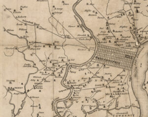
Blockley Township was incorporated in 1704 but was annexed by Philadelphia in 1854. Today’s maps no longer show any remnant of Blockley Township’s boundary. Perhaps where John Marshall initially settled, now Philadelphia County, is best remembered a street west of Philadelphia named Marshall. If you were within the limits of Philadelphia County in the 21st century, what area of the city could you visit to walk on land once owned by the Marshall family? On the map from 1752, right, you will see John Marshall’s later property indicated. The road to Philadelphia is named Marshall Road.
Answer
North America was a wide-open space for the early settlers and boundaries were often marked with rock formations and old-growth trees in property descriptions. Was Booth’s Corner or even Concordville in Chester or New Castle County (both are now in Delaware County)? When Penn arrived, the only well-defined borders were New Castle County’s 12-mile radius and the banks of the Delaware River for the most part. That means old records may have inaccurate locations documented as those who created the document were unsure of how boundaries had changed and were renamed over time. Maps, by today’s standards, were rare and very crude approximations in the 1700s. Research may be further muddled by previous historians propagating past errors of others. To attempt to reduce error, our work relies on more than a dozen old maps as well as historical records from multiple sources overlaid on current GPS informed mapping systems.
 To review Marshall family history, after King Charles II gave land in North America to William Penn in 1681, Penn solicitated fellow persecuted Quakers with an opportunity to settle in the New World he envisioned in America. Quaker John Marshall in his early 20s, took Penn up on his offer. Penn arrived in America in 1682 to find his colony expanding out from Philadelphia as he had directed. By the time John arrived in 1684, the wilderness west of Philadelphia was becoming colonized from three years of settlers arriving.
Penn directed three Pennsylvania counties, Bucks, Chester, and Philadelphia, (shown on the map left) created. There was New Castle County (formed 1673) already in existence to the south – the first of what would eventually become the ‘three lower counties’ of the Province of Pennsylvania (Delaware, as a self-governed territory of three counties, did not exist until 1776). The violet area alongside New Castle (map left; marked NCA-1 for non-county area) is land whose ownership was disputed between William Penn and Lord Baltimore at the time John Marshall arrived!
Philadelphia county, an area of roughly 10,000 acres consisted of the settlement of Philadelphia including adjacent land and the ‘Liberty’ territory further to the northwest (parts or all of 6 counties today). Bucks County was everything north to northeast of Philadelphia (parts or all of 10 counties today) while Chester County was everything south to southwest of Philadelphia County (parts or all of 15 counties today).
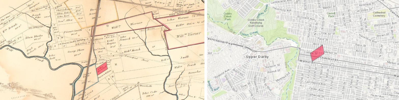
Being of limited means, Marshall settled in what at the time had become known as the Western Liberties west of the Schuylkill River. Penn gave land parcels in the Liberties to those settlers promising to work the land not only for their family’s needs but to provide additional bounty to help feed those living in Philadelphia. The first property Marshall purchased (red area on the two maps above; left map from Reed’s original Philadelphia landowners map; right is a ESRI Topo background and QGIS map) covered approximately 35 acres between present day 59th and 61st Streets and between Arch to Sansom Streets. Note that Reed’s map from 1846 shows Marshall Road crossing Cobb’s Creek at the left, passing a short distance south of the Marshall property, and connecting with the city. Walk within the red area marked above and you are walking what was once fields John Marshall toiled 340 years ago.
The Western Liberties area where John chose to settle would later be incorporated as Blockley Township in 1704. Blockley Township, an irregular area of 7,580 acres, was named for a parish in Gloucestershire, England. The Schuylkill River forms Blockley’s eastern border. Cobbs Creek, separating Philadelphia County from Delaware County, formed Blockley’s western border. Montgomery County, when formed, bordered Blockley to the north and the neighborhood of Kingsessing was to the south.
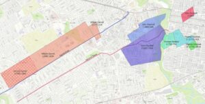 John Marshall eventually took title to additional land in Delaware County west of Cobb’s Creek. A Map of Philadelphia County by John Melish published in 1819 (right) shows the additional lands owned by John Marshall. The two properties John Marshall owned are noted in blue and purple on the map to the right and shown in reference to John’s first land (red).
John’s son, Thomas, and grandson, Thomas, Jr. owned land on the Blockley Township side of Cobbs Creek also shown on the map (green-shaded parcels). Note Marshall Road has become extended from Blockley Township into Delaware County. Subsequent maps drawn in the latter 1800s show various rerouting of Marshall Road within Blockley Township and Delaware counties but still carrying traffic to Philadelphia even after Blockley Township was absorbed into Philadelphia County.
Of interest on the map is the land belonging to William Garrett (light orange) that is northwest of John Marshall’s Delaware County land. We have learned from John H. Garrett, currently doing Garret Family genealogy research, that William was known as William “The Quaker” Garrett and was a man of means. The map shows land belonging to Samuel Garrett as well, William’s eighth born. Samual, likely purchased or inherited part of William’s land. Note Garrett Road passing along the southern border of the property and running parallel to Marshall Road.
We are going to close this answer to this week’s question with a note that the answer has been sifted from multiple sources including genealogy records, various publications, state and federal records, and multiple online resources. The conclusions presented are based on the available research uncovered to date. As new information is uncovered continuously, note that new information in the future may fine-tune the conclusions presented.
A difficulty with such work were the tools and methodology available to surveyors and those that drew maps from surveyor’s notes two centuries ago. Maps drawn in the 1700s and 1800s do not perfectly align with today’s precise maps from Google, Open Street, ESRI and FirstMap. Likewise, when Penn arrived, the Province of Pennsylvania had just been chartered (1681) and New Castle County was just eight years old! Chester County was everything north of New Castle County sans Philadelphia County which had been formed by Penn along with Bucks County.